|
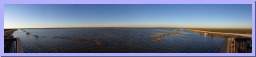
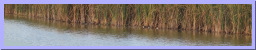
1200 x 135 Mon, Dec 28, 2009 |
 1200 x 241 Mon, Dec 28, 2009 |
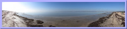
1200 x 160 Mon, Dec 28, 2009 |
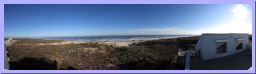
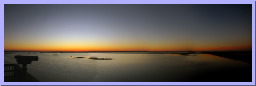 1200 x 379 Mon, Dec 28, 2009 |
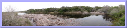
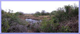
| Panoramic View of Wolfweed Wetlands, San Bernard National Wildlife Refuge | Panoramic View of Moccassin Pond, San Bernard National Wildlife Refuge | Panoramic View of Wolfweed Wetlands at Sunset, San Bernard National Wildlife Refuge | Panoramic View of Wolfweed Wetlands at Sunset, San Bernard National Wildlife Refuge |
|
1200 x 134 Tue, Dec 29, 2009 |
1200 x 142 Tue, Dec 29, 2009 |
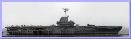
 1200 x 370 Tue, Dec 29, 2009 |
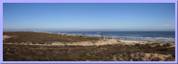
 1200 x 330 Tue, Dec 29, 2009 |
| Panoramic View of the from the Jetty, Mustang Island State Park, Padre Island, Tx | Panoramic View of the beach, Mustang Island State Park, Padre Island, Tx | Navy Planes on the deck of the USS Lexington, Corpus Christi, TX | Panoramic view of the Aircraft Carrier, USS Lexington, Corpus Christi, TX |
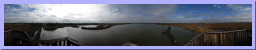
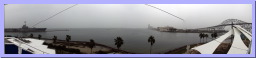 1200 x 244 Tue, Dec 29, 2009 |
1200 x 53 Wed, Dec 30, 2009 |
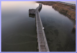
 1200 x 207 Wed, Dec 30, 2009 |
 1200 x 204 Wed, Dec 30, 2009 |
| Panoramic View of Corpus Christi Bay from Texas State Aquarium, Corpus Christi, TX | Panoramic view of Port Aransas Birding center, Port Aransas, TX | Panoramic view of ducks at Port Aransas Birding center, Port Aransas, TX | Panoramic view of from Observation Tower, Port Aransas Birding center, Port Aransas, TX |
|
1200 x 122 Wed, Dec 30, 2009 |
 1200 x 350 Wed, Dec 30, 2009 |
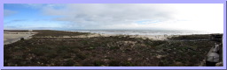
1200 x 58 Wed, Dec 30, 2009 |
1200 x 149 Wed, Dec 30, 2009 |
| Panoramic View from the Entrance Sign, Padre Island National Seashore | Panoramic View of Malaquite Beach from the Visitor Center, Padre Island National Seashore | Panoramic View of Padre Island from the Visitor Center, Padre Island National Seashore | Panoramic View of Malaquite Beach from the Visitor Center, Padre Island National Seashore |
|
1200 x 124 Wed, Dec 30, 2009 |
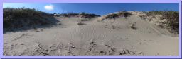 1200 x 371 Wed, Dec 30, 2009 |
 1200 x 320 Wed, Dec 30, 2009 |
 1200 x 414 Wed, Dec 30, 2009 |
| Panoramic View of Malaquite Beach, Padre Island National Seashore | Panoramic View of a Sand dune on Malaquite Beach, Padre Island National Seashore | Panoramic View of Malaquite Beach from the Visitor Center, Padre Island National Seashore | Panoramic View of Malaquite Beach from the Visitor Center, Padre Island National Seashore |
|
1200 x 131 Wed, Dec 30, 2009 |
1200 x 156 Wed, Dec 30, 2009 |
 1183 x 800 Wed, Dec 30, 2009 |
 1200 x 253 Thu, Dec 31, 2009 |
| Panoramic view of sunset, Port Aransas Birding center, Port Aransas, TX | Panoramic view of sunset, Port Aransas Birding center, Port Aransas, TX | Panoramic view of underwater tracks, Port Aransas Birding center, Port Aransas, TX | Panoramic View of Laguna Madre from JFK Causeway, Corpus Christi, TX |
 1200 x 245 Thu, Dec 31, 2009 |
 1200 x 495 Thu, Dec 31, 2009 |
1200 x 140 Thu, Dec 31, 2009 |
1200 x 197 Thu, Dec 31, 2009 |
| Panoramic View of Pond Heron Flats Trail, Aransas National Wildlife Refuge | Panoramic View of Pond Heron Flats Trail, Aransas National Wildlife Refuge | Panoramic View of Salt water March, Aransas National Wildlife Refuge | Panoramic View of Slough on Heron Flats Trail, Aransas National Wildlife Refuge |